Posts
Contact
Kristin Higgins
Public Policy Center
Phone: 501-671-2160
Email: khiggins@uada.edu
University of Arkansas System Division of Agriculture
Cooperative Extension Service
2301 S. University Avenue
Little Rock, AR 72204
New Watersheds Identified for Arkansas Priority List
For more than two decades, the state and nonprofit organizations have paid special attention to Arkansas watersheds by providing extra education and funding for streamside stabilization or improvement projects.

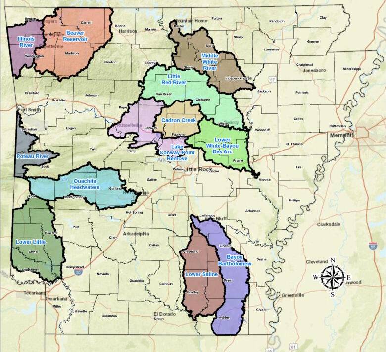
The Arkansas Department of Agriculture’s Natural Resources Division highlighted last week at the Arkansas Water Resources Center annual conference a new list of 12 priority watersheds for the years 2024-2029.
Being on the list increases the likelihood that communities and nonprofits in those watersheds can qualify for federal funds to educate residents and businesses about improving water quality or projects that address problems such as eroding streambanks.
What is a Watershed?
A watershed is defined as the land area that drains water to a particular stream, river or lake. It is a land feature that can be identified by tracing a line along the highest elevations between two areas on a map, often a ridge. Large watersheds like the Mississippi River basin contain thousands of smaller watersheds.
The U.S. Postal Service divides communities into zip codes to match mail to home addresses. Similarly, the U.S. Geological Survey divides the nation's landscape and geography into Hydrologic Unit Codes (HUC) to identify the boundaries of watersheds. Most organizations and state agencies talk about watersheds using the eight-digit HUC boundaries.
Arkansas has 58 watersheds at this eight-digit level, and the Priority Watershed List pulls from these watersheds.
How are Priority Watersheds Identified?
Twelve risk factors previously identified by people and groups interested in Arkansas' water quality determine which of the state’s watersheds ended up on that priority list (officially called Nonpoint Source Pollution Priority Watersheds.)
Factors include known problems with water quality, how local waterways are intended to be used, economic activity and development in the watershed, agriculture land use, unpaved roads, human population, forest land, and adjacent state priorities.
Natural Resources Division (NRD) staff partnered with FTN Associates to update the matrix of risk factors, which includes using the most recently available data to score each watershed. The University of Arkansas System Division of Agriculture previously worked with the state agency and stakeholders to develop the matrix.
Several watersheds on the current 2018-2023 list will roll off. They're replaced with watersheds that scored higher during the scheduled update, said Tate Wentz, NRD's water quality section manager. Land development played a role in those watersheds scoring higher, Wentz said.
Arkansas Nonpoint Source Pollution Priority Watersheds
The state's 58 watersheds, or areas where water drains to the same place, are ranked by those criteria listed above. The highest ranking watersheds, or 12 in this case, are then listed as priority watersheds. FTN Associates prepared slides explaining the ranking process.
| 2018-2023 Priority Watersheds | 2024-2029 Priority Watersheds |
|---|---|
| Bayou Bartholomew | Bayou Bartholomew |
| Beaver Reservoir | Beaver Reservoir |
| Cache River | Cadron Creek |
| Illinois River | Illinois River |
| Lake Conway-Point Remove | Lake Conway-Point Remove |
| L'anguille River | Little Red River |
| Lower Little | Lower Little River |
| Lower Ouachita-Smackover | Lower Saline |
| Poteau River | Lower White-Bayou Des Arc |
| Strawberry River | Middle White River |
| Upper Saline River | Ouachita Headwaters |
| Poteau River |
What is the Arkansas Nonpoint Source Pollution Management Plan?
Excessive sediment, nutrients and toxic metals prevent many Arkansas waterways from supporting aquatic life or other intended uses such as recreation, drinking, fisheries, agriculture and industry.
Nonpoint source pollution, or NPS for short, results from rainfall or melting snow moving over and through the ground. As the water moves, it picks up and carries with it natural and human-made pollutants, finally depositing them into lakes, rivers, streams, wetlands, or underground sources of drinking water. Unlike pollution from direct sources, such as industrial plants, NPS pollution can come from many sources that intermingle before reaching waterways.
In addition to a new new priority watershed list, the Natural Resources Division is also working on an updated Arkansas NPS Management Plan for stakeholders and the U.S. Environmental Protection Agency. The document helps state agencies, nonprofits, landowners, businesses and others to work together on improving the quality of water that runs off land and into Arkansas waterways.
Past plans included descriptions of each priority watershed along with helpful best management practices for land and streambanks. They also highlighted funding opportunities, emerging issues and impact of agriculture, forestry, erosion and urban runoff had on water quality in Arkansas.
Access past plans and other water quality policy information
The Public Policy Center previously facilitated annual discussions on the five-year plan and assisted the state with updates based on stakeholder priorities or new matrix calculations. We also hosted a series of educational events and public forums in priority watersheds to encourage residents to play a role in policy development and restoration practices.
Those efforts continue with the Arkansas Watershed Stewards program, a free educational course developed by stakeholders under the leadership of John Pennington, an extension water quality educator.