Ouachita Mountains
Contact
University of Arkansas System Division of Agriculture
Cooperative Extension Service
2301 S. University Ave.
Little Rock, AR 72204

Ouachita Mountains
Hoping to see better fall color in the Ouachita Mountains than I was seeing in the Ozarks, I headed south to Mena. Though the drought map didn’t show these mountains as critically dry as the Ozarks, the fall color was no better. But the drive along the scenic Talimena Drive is always a good way to spend a fall afternoon.
Rich Mountain has been the home of several Queen Wilhelmina lodges since the first was built in the late 1800s. At 2,681 feet, the long, narrow east-west trending Rich Mountain contains Arkansas’ second highest point. In 1969, the U.S. Forest Service and the state of Oklahoma paved the road west from the lodge to the end of Rich Mountain, creating Oklahoma 1. The opening ceremony for the new roadway was held in 1970 with Lyndon Johnson’s daughter Lucy cutting the ribbon. In 2005, the roadway was officially recognized as a National Scenic Byway.
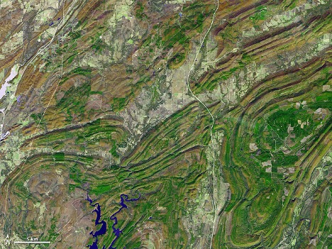
As a woodland drive, the Talimena Drive gives a good contrast with various Ozark roadways. The Ouachita Mountains are true mountains that were pushed up about 300 million years ago as the ancient landmass of Pangea was forming. At the time, Africa and South America were joined in one landmass called Gondwanaland. Tectonic plate movement, which chugs along at about the same rate our fingernails grow, pushed against the rocks formed at the bottom of the shallow sea separating what is North America from Gondwanaland to the south. These rocks had been forming for 200 million years as adjacent landmasses eroded.
This was no hit-and-run collision. The mountain chain that rose up extended along the coastal boundary of modern-day south-central Texas through Arkansas, eastward to Alabama and then north, pushing up the Appalachian Mountains. In the process of all this pushing and shoving, the earth’s crust sunk along the current Arkansas River forming the Arkoma Basin and then rose sharply, lifting the Ozark Plateau out of the water. About 200 million years ago the supercontinent Pangea began breaking up, Gondwanaland pulled away and fractured, with South America and African going their separate ways.
Speculation is that the Ouachita Mountains were once as high as the Rocky Mountains, which is a young range at about 50 million years of age. An important characteristic of geology is that as soon as a rock is exposed to the elements, it begins eroding. Over the 300 million years since they were first pushed up, the Ouachita Mountains and the Ozark Highlands have experienced a lot of erosion.
Though the Ozarks and Ouachita Mountains share a similar flora, the meandering rivers and crooked roads of the Ozarks are characteristics of random erosional features across an elevated, domed surface. But the uplifted east-west trending ranges of the Ouachita Mountains keep the rivers and future roadways in the bottoms of relatively straight valleys. Breaks in the ranges provide passes for the north-south roads that now traverse the region.
The Talimena Trail down Rich Mountain is, once you reach the summit, a nearly flat, almost straight roadway. In most places along the length of the drive, the spine of the mountain is only 100 to 200 yards wide. Plenty of pullout spots have been cleared so the traveler has ample opportunities to peer into the valley and look at the march of adjacent ridge lines in the distance.
A prominent feature of the Talimena Trail is the stunted character of the forest along the ridge top of Rich Mountain. These stunted trees are often called “Elfin Forests” because they are both small and very old. Representing one of the few virgin forests of our region, these scrawny trees were never cut. White oaks, scarcely more than a foot in diameter, have been cored to show they are 200 years old. Many of the 20-foot-tall post oaks growing in sumac-like thickets may also be quite old.
These elfin forests form because these ridge tops are extremely droughty spots during much of the year. Rainfall totals may average over 50 inches per year, but there is little soil to hold the moisture. And the high, narrow promontory provides lots of sun and wind to dry things out. It is not surprising the trees are stunted. It’s surprising they grow there at all.
When you drive through the Ozarks or the Ouachitas, look at the position of the rocks. In the Ouachita Mountains, the rock layers will usually be significantly tilted, and occasionally completely vertical. In the Ozarks, the rocks lie in a completely flat, boring bed, stacked like layers on a wedding cake.
